Map Projections and Mercator
Some current events have me thinking about cartography.
I've been teaching Human Geography for a handful of years now. Generally the way of it is that by your third year of teaching AP, you're finally starting to get a handle on it. As I said in a previous post, I am currently redesigning my curriculum again, and it so far feels like a success. The students are engaged, they're retaining, and they seem excited. Which is amazing because the first unit is also the most dull: Unit 1 is Thinking Geographically.
To quote College Board:
"This first unit sets the foundation for the course by teaching students how geographers approach the study of places. Students are encouraged to reflect on the “why of where” to better understand geographic perspectives. Many other high school courses ask students to read and analyze data, but for this course, students also apply a spatial perspective when reading and analyzing qualitative and quantitative data." (College Board Advanced Placement Human Geography Course and Exam Description)
It can be dry, but it's also extremely important. This unit is about completely reshaping how students think about the world, to dig into the root cause of things rather than accept surface level conditions. Human geography is about the connections we have to the physical environment, each other, and how those connections form the human experience. It's why I contend that it may be one of the most important classes offered to students. It's why I really wanted to shake up how I did this unit this year - because everything else is way more difficult if they struggle with spatial analysis. The beginning of the school year is hard to redesigning curriculum, but I knew I wanted to prioritize sharpening Unit 1.
The very first day of content is 1.1: Introduction to Maps. Students are introduced to the types of maps, how maps show space, and how maps can show different perspective depending on scale and distortion.
The Lesson Plan
Lecturing about maps is boring, so I instead decided to let my students compare map projections.
I give them two to start: the Mercator projection and the Gall-Peters projection. With their elbow partner, they must decide which one they believe is accurate, and why. The why is super important. The most common response I tend to get is Mercator, with the reasoning that it's the one they've seen the most. This reasoning falls apart under any level of sustained Socratic questioning.
There's usually at least one pair that figures it out: it's a trick question; neither is accurate because the Earth is 3D and maps aren't. I then set them to looking for distortions, using my one globe and comparing the two maps together. At some point, I also show a clip from The West Wing. Specifically, it's an episode from Season 2 where the Organization of Cartographers for Social Equality lobby the White House senior staff to adopt the Peters Projection map.
Then I introduce the Equal Earth map.
Why is the Mercator projection controversial?
The Mercator projection was introduced in 1596. The projection became extremely important for nautical pursuits.
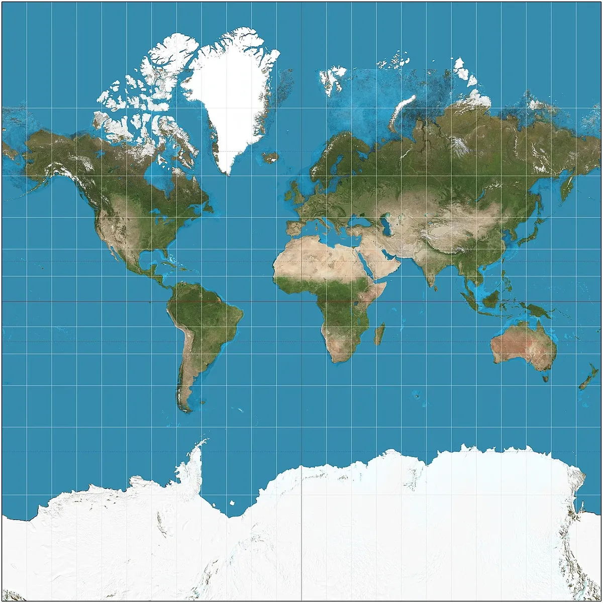
Mercator's projection introduces some extreme distortions by increasing the area in the northern part of the world, while diminishing it in the southern part of the world. It shifts the equator downward in the process. This is done to maintain the straight lines and direction across the Atlantic ocean. Remember, this is during the era of the Columbian exchange, when sea travel across the Atlantic was king. In short, it made travel easier.
The Mercator projection was widespread by the late 1800s, which is where the controversy stems. Critics argue that the Mercator projection, by shrinking the size of Africa/South America and increasing the size of North America and Europe, diminishes the visual significance of the shrunken areas; and this encouraged Europe's scramble for African colonization in the late 1800s, and US and European imperialism post-decolonization.
The opposition to the map is not over its use as a navigational tool, but its use as an educational one. A student looking at the same map over and over again will perceive these 'smaller' places to be less important throughout their life. This is because of a phenomenon in gestalt psychology. Basically, when we perceive things, our brains prioritize things that are larger and central. Remember the map above. Where did your eyes go first?
My eyeballs landed at the southern tip of Greenland, and then to the US/Europe, and then finally to Asia, Africa, and South America. Most of Africa is in the Northern Hemisphere, but the equator is so far below the focal point of the map, and Africa, South America, Southeast Asia, etc all come off as afterthoughts.
This is the basis behind the argument in favor of the Equal Earth projection over the Mercator projection. The Equal Earth projection is a compromise projection that attempts to preserve the relative size and position of land masses, while sacrificing distortions elsewhere. It's a better tool for teaching geography with than Mercator, and helping fight some of those long-held, dehumanizing biases that define imperialism.
This is why the United Nations voted to adopt it and, I'm sure, why the my own country voted against it. Which is honestly on brand for this administration.
Is it an accurate map? Overall, no. But like many questions in geography, there's some nuance here.
Is Mercator an accurate map projection? For it's purpose, yes: navigation across the Atlantic ocean.
Is the Equal Earth an accurate map projection? For equitable spatial understanding, I think yes.